Squally weather is expected to begin Friday night, with the greatest impacts Saturday as the storm's center passes about 220 miles west of Newton County.
By CJ Lester | Weather with CJ | Thursday, October 8, 2026
Hurricane Isaias is expected to bring gusty winds, bands of heavy rain and a risk of spin-up tornadoes to Oxford and the rest of Newton County from Friday night into Sunday, according to forecasts from the National Hurricane Center and the FOX 5 Storm Team.
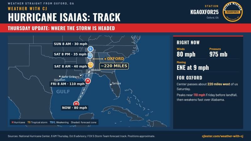
The storm's center is forecast to move ashore along the northern Gulf Coast and then track north through Alabama. At its closest point Saturday, the center is expected to pass about 220 miles west of Oxford.
Where the storm is now
As of the National Hurricane Center's 8 a.m. advisory Thursday, Isaias had maximum sustained winds of 80 mph and a minimum central pressure of 975 millibars. It was moving east-northeast at 9 mph over the Gulf.
The forecast calls for Isaias to strengthen to about 110 mph by Friday morning before reaching the coast. After landfall, the storm is forecast to weaken quickly as it moves inland, with sustained winds dropping to about 40 mph by 8 a.m. Saturday, 35 mph by 8 p.m. Saturday and 30 mph by 8 a.m. Sunday.
FOX 5 meteorologist Alex Forbes said Thursday that for most people in Georgia, the storm will be a gusty rain event. He said some areas could see downed trees and power lines, and a small number of people could be affected by spin-up tornadoes. Forbes said questions remain about how quickly the storm will weaken as it approaches land, but that the uncertainty has more effect on the forecast for Florida and Alabama than for Georgia.
Timeline for Oxford
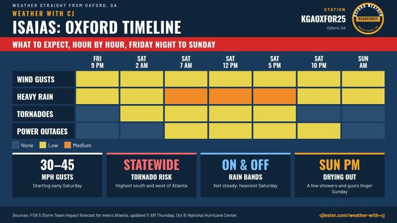
FOX 5's Thursday forecast lays out the following timeline for metro Atlanta and north and central Georgia, including the Oxford area:
- Friday after sunset: Squally, rainy weather begins and continues into early Saturday morning. The rain is expected to come and go rather than fall steadily.
- Early Saturday: Wind gusts of 30 to 45 mph begin. The risk of spin-up tornadoes starts a little before dawn.
- Saturday mid-morning through the afternoon: Rain bands move through as the storm's center passes to the west. FOX 5's impact forecast shows the heaviest rain from about 7 a.m. through 5 p.m. Saturday, and a low risk of power outages beginning Saturday morning.
- Saturday night: Conditions slowly taper off. The tornado threat is expected to diminish by late Saturday as the storm weakens and loses its tropical structure.
- Sunday: Lingering showers and gusts are possible, with drying expected Sunday afternoon.
Tornado risk
The tornado threat covers the entire state, according to FOX 5, with the highest threat south and west of Atlanta, including the LaGrange, Thomaston and Griffin areas. Oxford is outside that higher-risk zone but remains within the area where tornadoes are possible.
Tornadoes in tropical systems typically form in the storm's eastern, or right-front, side as it moves north. With the center passing through Alabama, Georgia will be on that side of the storm. These tornadoes, often called spin-up tornadoes, tend to be brief and can form quickly within rain bands, sometimes with little warning.
Wind and power
FOX 5 forecasts gusts of 30 to 45 mph across the region beginning early Saturday, with somewhat higher gusts possible in the highest elevations of north Georgia.
Hour-by-hour model projections shared by FOX 5 show Saturday wind gusts of 26 to 34 mph in nearby Eatonton and 22 to 33 mph in Athens. FOX 5's impact forecast shows a low risk of power outages from Saturday morning through Saturday night.
Rain
On Wednesday, the National Hurricane Center projected 1 to 3 inches of rain across much of the Southeast from Isaias, with localized amounts up to 5 inches.
For comparison, the Weather with CJ station in Oxford (KGAOXFOR25) recorded 0.56 inches of rain on Sunday, Oct. 4.
Safety information
The National Weather Service advises residents to have more than one way to receive warnings, including phone alerts set to sound overnight. During a tornado warning, the weather service advises moving to an interior room on the lowest floor of a building, away from windows. The weather service also warns drivers never to drive through flooded roads, as a few inches of moving water can sweep a vehicle away.
Follow live conditions
Live readings from the Weather with CJ station in Oxford, including rainfall totals and wind gusts, are available at cjlester.com/weather-with-cj. The page updates every five minutes.
Official watches and warnings are available from the National Hurricane Center at hurricanes.gov and the National Weather Service office in Peachtree City at weather.gov/atlanta.
Sources
- National Hurricane Center, Hurricane Isaias advisory, 8 a.m. Thursday, Oct. 8, 2026, as presented in the FOX 5 Storm Team forecast track graphic
- National Hurricane Center, Tropical Storm Isaias Public Advisory No. 3, 4 a.m. CDT Wednesday, Oct. 7, 2026 (rainfall projections)
- Alex Forbes, FOX 5 Atlanta, "Georgia 11 AM Thursday Update" Facebook post, Oct. 8, 2026
- FOX 5 Storm Team, "Hurricane Isaias Impacts – Metro Atlanta" forecast graphic, updated 11 a.m. Thursday, Oct. 8, 2026
- FOX 5 Storm Team, "Tornado Threat – Saturday" forecast maps, Oct. 8, 2026
- FOX 5 Storm Team, "Hour by Hour" GRAF model rain and wind gust projections for Saturday, Oct. 10, 2026
- National Weather Service tornado and flood safety guidance
- Weather with CJ station KGAOXFOR25, Oxford, Ga., observations for Oct. 4, 2026
Add comment
Comments