Heavy rain, gusty winds and a risk of spin-up tornadoes are possible here Saturday into Sunday as the season's first hurricane takes shape in the Gulf.
By CJ Lester | Weather with CJ | Wednesday, October 7, 2026
Tropical Storm Isaias formed in the Gulf early Wednesday morning, and it is expected to strengthen quickly into a hurricane before coming ashore along the northern Gulf Coast late this week. The center of the storm will stay well west of us, but Georgia will be on the side of Isaias that typically brings the most rain and the highest tornado risk.
Here's where things stand, what it means for Oxford and Newton County, and what you can do now to get ready.
Where Isaias is right now
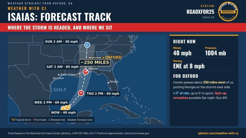
As of the National Hurricane Center's 4 a.m. CDT advisory Wednesday, Isaias was centered about 285 miles west of Progreso, Mexico, and about 580 miles southwest of the mouth of the Mississippi River. It had maximum sustained winds near 40 mph, a minimum central pressure of 1004 millibars, and was moving east-northeast at about 8 mph.
The storm grew out of Tropical Depression Nine, which formed Tuesday afternoon in the southwestern Gulf. Forecasters expect rapid strengthening over the next day or two, with Isaias becoming a hurricane by Thursday. If that happens, it will be the first Atlantic hurricane since October 2025.
No coastal watches or warnings were in effect as of early Wednesday, but the hurricane center said hurricane watches will likely be needed for part of the northern Gulf Coast later in the day.
Where it's headed
Isaias is expected to keep moving east-northeast today, then turn toward the northeast and north on Thursday and Friday. On that track, it passes north of the Yucatan Peninsula on Thursday and approaches the northern Gulf Coast on Friday.
The latest forecast track brings the center ashore near the Mississippi and Alabama coast early Saturday as a Category 1 hurricane with winds around 85 mph, after peaking near 90 mph over the central Gulf on Thursday. From there, the storm weakens as it moves north through Mississippi and Alabama, reaching the Tennessee Valley as a weakening low by early Sunday.
That path keeps the center roughly 250 miles west of Oxford at its closest point. That's far enough that we won't see hurricane conditions here. But it puts us on the storm's east side, often called the "dirty side," where the strongest rain bands and the conditions for tornadoes tend to set up.
What it means for us
Rain is the main threat. The hurricane center expects 1 to 3 inches of rain across much of the Southeast, with localized amounts up to 5 inches, as far north as the Tennessee Valley and the Carolinas. Closer to the coast, from far southeastern Louisiana to the Florida Panhandle, totals of 3 to 6 inches are expected, with some spots reaching 10 inches. Flash flooding, urban flooding and some river flooding are possible.
For reference, my station here in Oxford picked up 0.56 inches this past Sunday. This weekend could bring two to five times that, and more where heavy bands line up over the same areas.
Gusty winds. Steady winds of 20 to 40 mph are possible across north Georgia this weekend. That's enough to bring down weak limbs and toss around anything loose in your yard. Scattered power outages are possible, especially where the ground is soaked.
Spin-up tornadoes. This is the threat I'm watching most closely. Tropical systems can produce quick, short-lived tornadoes inside their rain bands, often with little warning. The name Isaias has history here: when a storm by that name hit the East Coast in 2020, it produced 39 tornadoes. Atlanta forecasters are highlighting the tornado potential especially Saturday night into Sunday, when many people will be asleep.
Timing
- Friday night: Clouds thicken, with a few showers possible late.
- Saturday: Rain bands move in and turn heavier through the afternoon. Winds pick up.
- Saturday night into Sunday morning: The heaviest rain and the highest tornado risk.
- Sunday: Conditions should gradually improve as the storm's remnants move north and away, though exact timing is still uncertain.
How to get ready
There's still time to prepare calmly before the weekend:
- Turn on emergency alerts on your phone, and make sure they're set to sound overnight. If you have a weather radio, put fresh batteries in it.
- Know your safe spot. If a tornado warning is issued, go to an interior room on the lowest floor, away from windows.
- Secure outdoor items like patio furniture, trash cans and decorations.
- Clear gutters and storm drains near your home so water has somewhere to go.
- Charge phones and power banks Friday in case the power goes out.
- Never drive through flooded roads. Just a few inches of moving water can sweep a car away. Turn around, don't drown.
The forecast can still change
Forecasters have noted that track and intensity are closely tied for this storm. Atmospheric conditions near the coast, especially strong winds high in the atmosphere known as wind shear, could limit how strong Isaias gets before landfall. A shift in the track of even 50 to 100 miles east or west would change how much rain and tornado risk we see here.
I'll keep updating as new information comes in. You can watch live conditions from my weather station in Oxford anytime at cjlester.com/weather-with-cj. It updates every five minutes, so you'll be able to see rain totals and wind gusts as the storm moves through.
For official watches and warnings, follow the National Hurricane Center at hurricanes.gov and the National Weather Service in Peachtree City at weather.gov/atlanta.
Sources: National Hurricane Center, Tropical Storm Isaias Advisory No. 3 (4 a.m. CDT, Oct. 7, 2026) and forecast track; Atlanta News First; FOX 5 Atlanta; FOX Weather; CBS 17. Live observations from Weather with CJ station KGAOXFOR25, Oxford, Ga.
Add comment
Comments